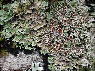
Phormopsora isabellina (Vain.) Elvebakk, S.G. Hong & C.H. Park, comb. nov.
MycoBank number: MB 837376; Index Fungorum number: IF 837376; Facesoffungi number: FoF 13342;
≡ Psoroma isabellinum Vain. in Hedwigia 38: 188(1899)
≡ Pannaria isabellina (Vain.) Elvebakk & Bjerke in Lichenologist 37: 48 (2005).
Types: ‘Ad truncus arborum 1000 m s. m, in regionibus silvosis andini in Chili, Neger n. 94 (holotype TUR-V!, isotype M, isotype designated here) (Fig. 4).
Phormopsora isabellina was thoroughly treated (as Pannaria isabellina) by Elvebakk and Bjerke (2005), including morphology, anatomy, and chemistry, with several illustrations, including one SEM picture showing ascospores deposited on an apothecium disc. The habitat was described, and the species was shown to be common in the Lago Llanquihue and Lago Todos Los Santos areas in the X Region of Chile, as indicated by 11 collections cited from this area. In addition, two more localities were cited further north in what is now the XIV Region, whereas three additional localities were cited from the huge XI and XII Regions of Chile. For these aspects Elvebakk and Bjerke (2005) is referred to. Since then, the species has been cited from Argentina (Passo et al. 2008), from Isla Mocha in Región VIII del Bío-Bío of Chile by Quilhot et al. (2010), and from the XI Region of Aisén by Quilhot et al. (2012).
Additional specimens studied (26): CHILE. IX Región de la Araucanía: Parque Nacional Nahuelbuta, Pehuenco, 37° 36′ S, 72° 48′ W, c. 1300 m, 11 Dec. 2007, A. Elvebakk 07:326; 327 (TROM); c. 5 km W of Malalcahuello, S of the mouth of the valley Estero Huamachuco, 38° 27′ 50.5″ S, 71° 38′ 03.4″ W, 880 m, 13 Dec. 2009, A. Elvebakk 09:109 (TROM); 1. 2 km S of SE boundary of Reserva Nacional Malalcahuello, 38° 34′ S, 71° 30′ W, 1400 m, 13 Dec. 2009, A. Elvebakk 07:385 (TROM); Parque Nacional Villarica, 1000 m, 4 Dec. 1978, W. Quilhot (UV); X Región de los Lagos: Ensenada am Llanquihue-See, 26 Jan 1961, F. Mattick 536 (B 28774); Petrohué Sur, mayo 1974, J. Redon 03105 (UV); Lago Yelcho, Playa Cari, 28 Nov. 1993, W. Quilhot (UV); XI Región de Aisén: NE of Puerto Aysén, 15 km S of Lago las Torres, 44° 56.721′ S, 72° 09.768′ W, 270 m, 11 Dec. 2006, A. Elvebakk 06:428A; 06:432A; 06:435; 06:432B; 06:441 (TROM); C. 13 km N of Puerto Aisén, along road 1–5 km N of laguna de los Palos, 45° 17′ S, 72° 46′ W, 40 m, 31 Jan. 1989, L. Tibell 18121a (UPS L-31042); Valle de Río Simpson, Puente Las Pizzaras, 45° 28.111′ S, 72° 18.367′ W, 9 Dec. 2006, A. Elvebakk 06:404; 06:413 (TROM); Parque Nacional Queulat, Río Ventisquero, 1 km E of Carretera Austral, 44° 28.276′ S, 72° 33.68′ W, 20 m, 11 Dec. 2006, A. Elvebakk 06:503; 06:526A (TROM); Miradór del Ventisquero, 300 m W of W end of laguna Tempanos, 44° 28.161′ S, 72° 32.673′ W, 30 m, 11 Dec. 2006, A. Elvebakk 06:506 (TROM); 19 km along the road W of Puerto Río Tranquilo (= c. 10 km W of Lago Tranquilo), 46° 37.488′ S, 72° 51.623′ W, 320 m, 28 Nov. 2007, A. Elvebakk 07:049 (TROM); 50 km N of junction Carretera Austral and road to Tortel, 2.5 km N of Puente Los Ñadis, 47° 35.208′ S, 72° 51.894′ W, 100 m, 2 Dec. 2007, A. Elvebakk 07:222 (TROM); 4 km E Caleta Tortel, along the road, and near the river, 47° 48.073′ S, 73° 29.199′ W, 10 m, 3 Dec. 2007, A. Elvebakk 07: 252 (TROM); Valle Explotadores, near Cabañas Alacalufes, c. 3 km E of Lago Bayo, 46° 30′ 26″ S, 73° 03′ 53″ W, 250 m,, 29 Nov. 2007, A. Elvebakk 07:106A (TROM); near W part of lago Bayo, 46° 29.514′ S, 73° 07.292′ W, 150 m, 29. Nov. 2007, A. Elvebakk 07:077 (TROM); XII Región de Magallanes: Comúna Cabo de Hornos, Parque Nacional Cabo de Hornos, Islas Wollaston, SE coast of Isla Grevy, Península Low, 55° 34′ 53″ S, 67° 36′ 27″, 24 Jan. 2014, W.R. Buck 62,944 (NY); Península de Brunswick, c. 13 km N of Cabo San Isidrio and c. 2.8 km S of bridge over Río San Pedro. 53° 43′ 52″ S, 70° 58′ 01″ W, 5 m, 6 Dec. 2012, A. Elvebakk 12:156 (TROM).

Fig. 4 Phormopsora isabellina photographed in the field in Chile, specimen Elvebakk06:503 (TROM)
